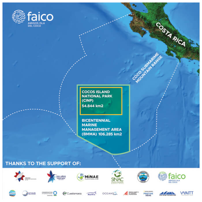
Bicentennial Seamounts Marine Management Area
In Costa Rica, a Marine Management Area is a management category for a protected wild area, coastal marine or oceanic, created to guarantee the protection and maintenance of marine biodiversity in the long term and that generates a sustainable flow of natural products and environmental services to the communities. Its zoning allows certain extractive and non-extractive uses, as long as they comply with environmental responsibility standards. However, this category does not allow: i) fishing with trawl nets, ii) semi-industrial and industrial fishing, or iii) oil exploration and exploitation.
The Seamounts Marine Management Area (AMM-MS) is the first Protected Wildlife Area declared under this management category in Costa Rica. It was created on June 23, 2011, through Executive Decree No. 36452-MINAE. It measures 9640 km2 and is located in the Pacific Ocean, in the waters around Cocos Island National Park.
It is created with the aim of conserving: i) a representative sample of the marine ecosystem that is characteristic of the underwater Cocos mountain range, ii) aggregation sites of fish species of fishing importance, both for commercial and for sports purposes, iii) transit areas and fishing sites; aggregation of pelagic fish, cetaceans, and marine turtles, especially species that are threatened and endangered, iv) transit areas and aggregation sites of migratory species, and v) deep coral formations.
The marine seamounts are comprised by a group of 15 submarine structures, including the location of Cocos Island and additional minor structures that extend less than 200 km to the west and southwest of the island (Pacheco et al., 2008). The high productivity of these geological formations, mainly of the shallowest ones, is reflected in the amount of species that are grouped in them, with a biomass that is higher than in other sites with less complexity. In addition, the protection of these deep ecosystems tends to integrate delicate habitats and vulnerable species of flora and fauna (Morato et al 2004).
Due to its structure and the influence of currents, the AMM-MS is a migratory passage for different species: for those that move from the coast to oceanic waters, as well as for those that migrate between the islands of the Eastern Tropical Pacific Corridor.
This protected area is under the administration of the Cocos Marine Conservation Area (ACMC) of the National System of Conservation Areas (SINAC), an entity of the Ministry of Environment and Energy (MINAE).
The conservation objects identified as priorities for the AMM MS Management Plan are:
i) benthic ecosystems (seamounts);
ii) pelagic ecosystems;
iii) fish of commercial importance; and
iv) migratory species.
The main threats identified that may directly affect the ecological integrity of the AMM MS are: i) illegal fishing, ii) transshipment of fuel between vessels or fuel spills, iii) effects of the ENSO phenomenon – El Niño/La Niña and the impacts of climate change, and iv) physical and chemical changes of the great Eastern Tropical Pacific ecosystem.
The Management Plan for Wild Protected Areas (WPA) is the guiding instrument for effective administration and management of natural and cultural elements present in protected areas. It is the technical tool through which each WPA establishes management guidelines to be used by managers, administrators, and stakeholders. You can find the General Management Plan for the AMM Marine Seamounts here.
Bibliography
- Decreto Ejecutivo: 36452 del 03/03/2011. “Crea Área Marina de Manejo Montes Submarinos”
- Decreto Ejecutivo: 38327 del 11/04/2014. ”Oficializa Plan de Manejo del Área Marina de Manejo Montes Submarinos”
- Morato, T., Cheung, W.L. & Pitcher, T.J. 2004. Vulnerability of seamount fish to fishing: Fussy analysis of life history attributes. In: Seamounts: Biodiversity and Fisheries.Fisheries Centre Research Reports 12(5): 51-60.
- Pacheco, O., Ballestero, D., Sierra, L., Jiménez, R., Quesada, R., y Acevedo, E. (2008).
Propuesta para la Conservación de la zona marina adyacente al Parque Nacional Isla del
Coco. Universidad Nacional, Heredia, Costa Rica. 130 pp
- SINAC (Sistema Nacional de Áreas de Conservación). 2013. Plan de Manejo del Área Marina de Manejo de Montes Submarinos (AMM MS), Costa Rica. Área de Conservación Marina Isla del Coco (ACMIC). San José-Costa Rica. 102 p.


